This week’s crop of new applications are in postcodes UB10 8… then HG, LF, LW, QD, QU, RH and SA. Map link.
Category Archives: Resources
Breakspear Road South closure
This has just come in from Hillingdon Neighbourhood Watch:
Breakspear Road South will be closed from Breakspear Road to the junction with Swakeleys Road for six weeks from 20th July until 4th September for major GAS work.
This will obviously have a major impact on traffic flow in the area.
[ And something that HS2 could learn much from – Ed ]
Planning updates 04-07-2016
This week’s crop of new applications are in postcodes UB10 8… then BD, EG, EH and EU. Map link.
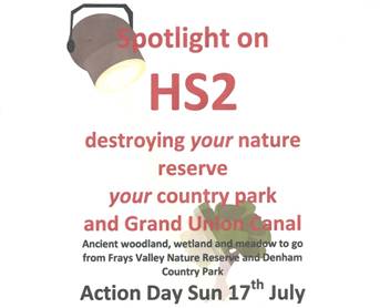
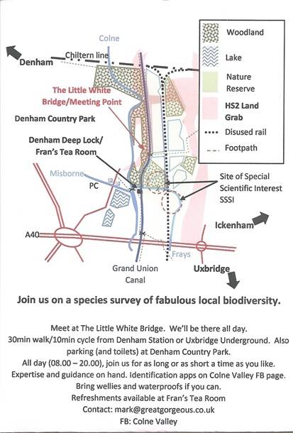
HS2 threat to our heritage
As you know, part of the Colne Valley is in the western reaches of Ickenham. The proposed HS2 works will bisect the valley and cause considerable environmental harm. The following documents tell you all you need to know about a planned action day on July 17th:
Planning updates 27-06-2016
This week’s crop of new applications are in postcodes UB10 8… then DP, EH, EU, HE, HU, NR, QA, QZ, RA, RW, SD and SZ. Map link.
Planning updates 20-06-2016
This week’s crop of new applications are in postcodes UB10 8… then BG, DS, HT and SZ. Map link.
Planning updates 13-06-2016
This week’s crop of new applications are in postcodes UB10 8… then AN, HF, HP, JH, PN, QG, QJ and RT. Map link.
Spring 2016 Newsletter added to archive
Hillingdon Neighbourhood Watch
Hillingdon Neighbourhood Watch provides an excellent place to catch up on crime news and advice. It provides useful links to resources, including prevention products and services, including the occasional special pricing (or free) offers. We’ve just added it to the Useful Links section of this website.
Pinn depth monitor at Swakeleys Road
If you are concerned about flood risk or the chance of being washed downstream, this GaugeMap link shows the state of the River Pinn. Here’s a snapshot:

You can alter the frequency and tweak other graph options. In the snapshot, the upper black line is the highest ever recorded (October 30th 2000) and the second line is the more recent highest (February 7th 2014). The lower black line is the lowest ever recorded (August 9th 2007).
