
| From the minutes of the meeting held on 22nd October Minutes: RESOLVED: That the Cabinet: 1) Note the need for changes to the existing Garden Waste Service to increase recycling rates further and ensure best use of public resources. 2) Agree that the Garden Waste Service moves to a consistent fortnightly service for the entire year with 25 collections per year, starting from April 2027; 3) Agree that the service be delivered via wheeled bins; 4) Agree that charges be set on a per bin basis and in the first year at £69 per bin, representing a £8 reduction in charges for entry level (one bin) residents with a charge of £69 for each additional bin; 5) Agree to hire sufficient appropriate vehicles to deliver a bin-based service until such time as suitable Refuse Collection Vehicles (RCVs) with bin lifting equipment are procured (noting an industry 18-to-24-month delivery timescale); 6) Agree the commencement of a procurement exercise for the required replacement of refuse collection vehicles (RCVs) to provide this service, noting any associated capital release will be requested once the procurement exercise has completed; 7) Agree the commencement of a procurement exercise for 40,000 bins and their delivery at a value of circa £1.2m, noting this will provide for all existing residents who subscribe, allow some growth and retain a stock for future replacement and growth; 8) Approve a budget virement from the Council’s Capital Contingency budget of £1.2m to create a new capital programme for the purchase of Garden Wheeled Bins and approve the capital release of £1.2m from the newly created capital programme for Garden Wheeled Bins. 9) Delegate authority to the Corporate Director of Residents Services, in consultation with the Cabinet Member for Residents Services, to: a. award the green waste bin contract via a compliant procurement framework; b. finalise the bins design, including colour wording and logo; c. agree and put in place the necessary operational policy framework around wheeled bins, such as property suitability, charges for replacements and placement for collection. Cabinet therefore agreed the recommendations in the report. Item 5 in the minutes |
M25 closure J15 update
Update: M25 junction 15 anticlockwise closures (8pm to 10am)
Connect Plus Services works on behalf of National Highways and Connect Plus to manage, operate and maintain the M25 and its linking roads, including the Dartford-Thurrock River Crossing.
I’m writing to let you know that we have postponed this weekend’s planned closure at M25 junction 15 due to forecast adverse weather conditions.
As a result, the M25 junction 15 anticlockwise carriageway will no longer be closed between 8pm on Saturday 24 October and 10am Sunday 25 October 2026.
Instead, we’ll need to use a contingency closure to complete this work the following weekend. The M25 junction 15 anticlockwise carriageway, above the M4, is now scheduled to close: From 8pm Saturday 31 October until 10am Sunday 1 November 2026
The M25 junction 15 clockwise carriageway and all links between the M25 and M4 will remain open throughout the works.
Diversion route During the closure, M25 anticlockwise traffic will need to exit at junction 15. There will be a fully signed diversion route in place to rejoin the M25 anticlockwise carriageway after the closure: follow the M4 westbound to junction 5 turn around at M4 junction 5 (the Langley Interchange) return on the M4 eastbound to rejoin the M25 anticlockwise via M4 junction 4b
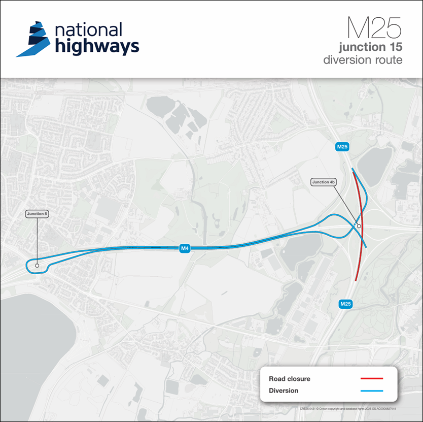
The route will be busier than usual, with residual delays expected on the M25 on Sunday after the closures have been removed.
If you must travel between these times Please plan ahead and allow extra time for your journey. Travel earlier or later in the day – we’re expecting the busiest time around the M25/M4 interchange on Sunday mornings between 8am and midday.
Where possible Consider alternatives to avoid severe delays, including alternative routes or public transport (i.e., for Heathrow Airport, Heathrow Express, Elizabeth Line). We’ll complete some further works on weekday nights. These closures will take place between 10pm and 6am. During weekday nights, a diversion will be in place to M4 junction 4 and return. M25 junction 15 anticlockwise weeknight closures diversion route map You can find information about this work and updates on the scheme webpage.
https://nationalhighways.co.uk/roads-and-travel/road-projects/south-east/m25-junction-15-m4-junction-4b-bridge-repairs-near-heathrow-airport/
Please remember that closures can change at short notice. For the latest roadworks information, please visit www.nationalhighways.co.uk/travel-updates. We sincerely apologise for any inconvenience and thank you for your patience and cooperation while we complete this essential work. If you require any further information, please don’t hesitate to contact us: By phone: 0300 123 5000 By email: info@nationalhighways.co.uk www.nationalhighways.co.uk Kind regards Ben Evans Scheme Communications Manager
Harvil Road footway closure
HS2/SCS has requested a Footway Closure on Harvil Road around the Gate 2.5 Bellmouth (where the Railway Siding Access Road is) to allow them to carry out some Drainage works within the Footway.
They will close the section of Footway over School Half Term week from Mon 26/10 to Fri 30/10.
There will be no carriageway incursion. Signage will be in place to divert pedestrians to use the pedestrian refuge islands to cross the road safely as required.
Planning updates to 19-10-2026
Harvil Road temporary traffic signals
Harvil Road 2-Way Traffic Lights by junction of Highfield Drive for Affinity Water works – Sat 24/10 to Sun 01/11
2-Way Traffic Lights on Harvil Road by the junction with Highfield Drive for Affinity Water works will be introduced between Sat 24/10 and Sun 01/11. These works are not HS2 related and will take place during the School half-term break in Hillingdon.
Garden Waste and Poo Bins
| Garden Waste Service Review and Future Design Options https://modgov.hillingdon.gov.uk/documents/s68113/05%20-%20REPORT%20Executive%20Decision%20Report%20GW%20V1%201.pdf highlights 1)Agree that the Garden Waste Service moves to a consistent fortnightly service for the entire year with 25 collections per year, starting from April 2027; 2) Agree that the service be delivered via wheeled bins; 3) Agree that charges be set on a per bin basis and in the first year at £69 per bin, representing a £8 reduction in charges for entry level (one bin) residents with a charge of £69 for each additional bin; 5) Agree to hire sufficient appropriate vehicles to deliver a bin-based service until such time as suitable Refuse Collection Vehicles (RCVs) with bin lifting equipment are procured (noting an industry 18-to-24-month delivery timescale The transition period is scheduled to begin in April 2027, once the new rounds have settled the service will commence implementing the new system, seeking to dual operate systems until April 2028. The transition period will also include system testing, staff training, data validation and parallel operational monitoring to ensure the new platform is fully functional before becoming the primary operational system As the Garden Waste Collection Service is a discretionary, chargeable service and the proposal concerns changes to the operational method of service delivery rather than the withdrawal of the service, it is not proposed to undertake a public consultation Where a property is unsuitable for the use of a wheeled bin, alternative sack-based arrangements will continue to be available. In addition, the Council’s existing assisted collection service will remain available for residents who are unable to present their containers due to age, disability or other qualifying circum- stances Hillingdon wants to remove every dog waste bin in the borough, without asking residents https://www.ruislipresidents.org.uk/remove-dog-poo-bins/?fbclid=IwdGRzaAU-VndjbGNrBT5UtGV4dG4DYWVtAjExAHBkb2YFc3J0YwZhcHBfaWQMMzUwNjg1NTMxNzI4AAEe6u7M_-Maxk1ereja3KyHu_BAJhobaWd8Y5Xqnv58jJnC74hMjIcMNd2spXQ_aem_PcNQvn6GyvbqMFBgMj2d4Q The dog waste bin on your regular walk could be gone by the end of January. The Council wants to remove all 700 of them and hasn’t asked residents what they think. Dog owners would be told to put their poo bags in ordinary litter bins, or take them home. A report dated 14 October asks Cllr Wayne Bridges, Cabinet Member for Residents’ Services, to approve the removal of all 700 or so standalone dog waste bins in Hillingdon. Dog owners would be told to use ordinary litter bins or take the bag home. It is a decision for Cllr Bridges alone, who can sign it off from Thursday 22nd October. The report says no formal public consultation has been carried out or is proposed. The Residents’ Services Select Committee can call the decision in before it takes effect, but only has five working days to do so. If Cllr Bridges signs on 22nd October, stickers reading “I can take dog waste too” could start appearing on selected litter bins from mid-November, and the dog waste bins could start to disappear from late January. |
Planning updates to 12-10-2026
HS2 Drop-in 22 October
An SCS Community Engagement Drop-in event at Ickenham Village Hall is coming up:
- Date: Thursday 22 October 2026
- Time: 4pm – 7pm
- Location: Ickenham Village Hall, Ickenham, UB10 8DG
Air Quality action plan
| FROM LBH We would just like to advise you of the current consultation being run by Hillingdon Councilmembers. Please click on the link below https://pre.hillingdon.gov.uk/consultations-surveys/air-quality-action-plan-2026-2030-consultation Air quality action plan 2026 to 2030 consultation | Hillingdon Council Please do get involved and have your say. Thank you for your continued support. |
Swakeleys Park lake clean-up warning
| PLEASE DO NOT ENTER THE BASIN OF SWAKELEYS LAKE – IT IS POTENTIALLY VERY DANGEROUS We have received the following from the green spaces team @ LBH I’m writing because I’ve been made aware that a litter-picking group is advertising an event at Swakeleys Lake on Sunday, and I wanted to make sure everyone is aware of the safety risks associated with entering the lake basin. Last month, the Woodlarks and Waders volunteers carried out a clean-up session at the site. Although the lake basin appeared dry, the ground was actually extremely soft, and two very experienced volunteers became stuck in the mud. Entering the basin is therefore not something I would recommend. In places, it is quite literally like quicksand. One of the volunteers also recently contacted me to let me know that he had already litter-picked the area and removed a large quantity of rubbish, including bikes, cones and signs , all of which has since been collected. The stream was also cleared by the same volunteer group earlier this year, so a significant amount of work has already taken place. June Reyner On Behalf of Ickenham Residents’ Association www.ickenhamresidents.co.uk www.twitter.com/ickenhamra to reply to this email please use ickenhamresidents@hotmail.com want to update / amend your profile https://ickenhamresidents.us14.list-manage.com/profile?u=6eeb0bb30b5b90d6777a24c37&id=ff7eb32754&e=60c4f5ad0e&c=6fcb11000d Want to change how you receive these emails? You can unsubscribe from this list  |

