
The list from yesterday includes applications from Swakeleys Road, Three Oaks Close, and High Road. Check out all outstanding applications on our interactive map.
Reducing HS2 HGV movements and spoil dumping
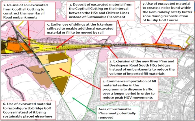
HS2, LBH and TfL have been working on ways to reduce the likely impacts of HS2 development in our locality. The full report is due in May, but an interim report shows the seven shortlisted initiatives related to HGV movements and spoil dumping.
Here’s an overview map. One of the most interesting ‘sustainable placement’ initiatives is unnumbered.
Recent planning applications
This week’s plannning applications are in Glebe Avenue, Swakeleys Drive, Swakeleys Road and Woodstock Drive. See our map of live applications. (Recently approved or rejected applications are removed.)
Police contact points
Please don’t abuse these contacts. 101 is great for non-emergencies and 999 for genuine emergencies. Here are all the local contact points:
If you have a local issue, contact your Safer Neighbourhood Team sergeant by email:
- Sgt David Peaks | Ickenham and Harefield | david.j.peaks@met.police.uk
- Or phone your local Safer Neighbourhood Ward Officer:
- Ickenham 020 8721 2543
- If they are off duty, their phone will divert to voicemail that will be answered within 24-hours
Phone 999: Emergencies
Phone 101: Non urgent
And then there is always Inspector Rob Bryan, Hillingdon North Safer Neighbourhoods | Hillingdon Borough
- Phone 020 8246 1816 | Mobile 07500 097 182
- E-mail robert.bryan@met.police.uk
- Twitter @MPSHillingNorth
- Address Ruislip Police Station, The Oaks, HA4 7L
Ickenham’s Green Belt land
Thanks to an interactive mapping service provided by The Telegraph, we’ve been able to plot the Green Belt parts of Ickenham. Link to the original for exact detail, but here’s a close approximation (the darker green is Green Belt):

We’re “genteel” (it says here)
Trawling around looking for a definitive Green Belt map for Ickenham (here’s a clue), I noticed this description of Ickenham in Hidden London. We are, apparently, “A genteel residential suburb situated between Uxbridge and Ruislip.”
Hidden London claims to take, “an informative, historically inclined look at a variety of the capital’s more obscure attractions, curiosities, districts and localities.”
Planning map updated
Because of the extended Easter weekend, just a few updates this week. See Planning Applications map
Planning map updated
Every Monday, we receive planning updates. We then see how quickly we can get the live applications (i.e. undecided) online. Not very quickly, this week. But they’re all there now.
Result! (Ickenham plan)
Much more to come, no doubt, from Ickenham Plan but about 100 people attended the debut meeting today at the Village Hall. At the end they decided that it would be a good idea to create a Neighbourhood Plan to help preserve and improve Ickenham as a wonderful place to live.
Well done Ickenham Residents’ Association Committee member, Chris Mountain, for his hard work today, at the festive evening and on many occasions in between to start the ball rolling.
The intention is for the Neighbourhood Plan to have its own organisers, independent of the Ickenham Residents’ Association, although some Committee members might want to join in as private individuals. The truth is that the Committee has plenty on its plate already and might not be able to give the new plan the attention it clearly deserves.
Conservation area map
If you’re curious about where the Conservation Area is in Ickenham, the new map will give you a general idea. A link on the page takes you to LBH’s version.
Here’s a preview:


