
Hello, I hope you know your post code because these are the UB10 8 prefixed codes for all the new planning submissions this week: AA, AF, AG, BD, BP, DF, EG, JE, NB, QY, RA, RL, SA, SR, SZ, TH. (There’s a slight danger that two of them are repeats from an earlier update – my apologies if that’s the case.)
Category Archives: Environment
The House of Lords starts work on HS2
Here’s a note from Brian Adams, Committee member and one of our leading HS2 petitioners, about the second reading of the High Speed Rail (London-West Midlands) bill on April 14th:
“It is good to see that some Lords understand the disenchantment of the communities and many of the issues.”
“Note the comment that they should start first with petitions from London and AFTER the summer recess.”
http://stophs2.org/news/15414-lords-say-to-petition
If you don’t want to take Stop HS2’s word for it, or want to explore the context more deeply, take a look at the Hansard transcript.
Your HS2 Compensation questions answered
Many Ickenham residents are confused and worried about HS2’s plans for compensation (Assuming we don’t get the tunnel). In January, it published some maps and explanations of the various types of compensations on offer. We’ve extracted the Ickenham-relevant parts and put them on a new HS2 Compensation maps page. This links to three downloadable maps in .pdf format which you can browse at leisure (and zoom into to see the detail).
While researching HS2 compensation in general, we found a link to good plain english explanations by property consultants Roger Hannah & Co – well worth a look.
Recent planning applications
The list from yesterday includes applications from Swakeleys Road, Three Oaks Close, and High Road. Check out all outstanding applications on our interactive map.
Reducing HS2 HGV movements and spoil dumping
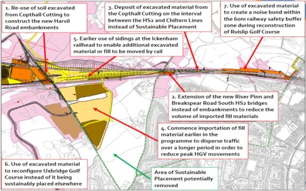
HS2, LBH and TfL have been working on ways to reduce the likely impacts of HS2 development in our locality. The full report is due in May, but an interim report shows the seven shortlisted initiatives related to HGV movements and spoil dumping.
Here’s an overview map. One of the most interesting ‘sustainable placement’ initiatives is unnumbered.
Recent planning applications
This week’s plannning applications are in Glebe Avenue, Swakeleys Drive, Swakeleys Road and Woodstock Drive. See our map of live applications. (Recently approved or rejected applications are removed.)
Ickenham’s Green Belt land
Thanks to an interactive mapping service provided by The Telegraph, we’ve been able to plot the Green Belt parts of Ickenham. Link to the original for exact detail, but here’s a close approximation (the darker green is Green Belt):

We’re “genteel” (it says here)
Trawling around looking for a definitive Green Belt map for Ickenham (here’s a clue), I noticed this description of Ickenham in Hidden London. We are, apparently, “A genteel residential suburb situated between Uxbridge and Ruislip.”
Hidden London claims to take, “an informative, historically inclined look at a variety of the capital’s more obscure attractions, curiosities, districts and localities.”
Planning map updated
Because of the extended Easter weekend, just a few updates this week. See Planning Applications map
Planning map updated
Every Monday, we receive planning updates. We then see how quickly we can get the live applications (i.e. undecided) online. Not very quickly, this week. But they’re all there now.

